WSIL -- One more very warm afternoon with near record temperatures!
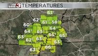
Early morning temperatures are shattering warm low records. The entire region is in the mid to upper 60s as cloudy skies take hold and winds pick up from the south.
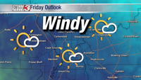
Afternoon records are in the lower 80s, which we'll likely come up just shy of making a run at. High temperatures will peak in the upper 70s and it will be windy. Winds are expected to gust up to 30 miles per hour.
The daylight hours will remain dry, though a couple showers are possible later in the afternoon south of the Ohio River into western Kentucky.

A strong cold front is expected to arrive this evening, signaling an end to our near record warmth. Showers and possibly a few rumbles of thunder are possible along the cold front, but severe storms are likely to remain north of the area.

Join Meteorologist Nick Hausen on News 3 This Morning for the latest!