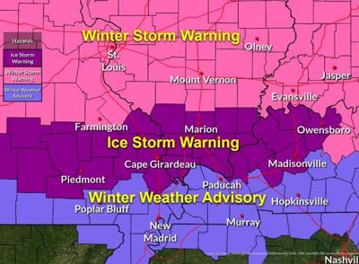
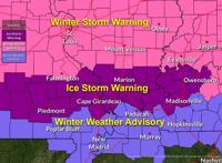

CARTERVILLE, Ill. (WSIL) -- Ice Storm Warnings and Winter Storm Warnings have been issued for most of the region. This includes mostly southern Illinois and southeast Missouri. A Winter Weather Advisory is in effect for mainly those in the southern counties of southeast Missouri, western Kentucky and northwest Tennessee.
The warnings were issued starting at 2 a.m. on Sunday and last through 6 a.m. on Monday.
The wintry mix should start in the early morning hours on Sunday and cause significant ice buildup on the ground.
For those in the Ice Storm Warning, up to two inches of snow and sleet accumulations are expected in this area with .25 - .75 inches of ice accumulations.
For those in the Winter Storm Warning area, three to five inches of snow and sleet are possible with .2 - .5 of an inch of ice accumulation.
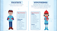
The roads are expected to become extremely slick so traveling during this time is strongly discouraged. However, if you must be out, please make sure you have a winter kit available for emergencies. This can include items like food, water, blankets, etc. Click here to find out what should be in your winter kit.
Below are the counties included in the Ice Storm Warning...
Illinois
- Alexander
- Gallatin
- Hardin
- Jackson
- Johnson
- Massac
- Pope
- Pulaski
- Saline
- Union
- Williamson
Kentucky
- Caldwell
- Crittenden
- Daviess
- Henderson
- Hopkins
- Livingston
- McLean
- Union
- Webster
Missouri
- Bollinger
- Cape Girardeau
- Carter
- Perry
- Scott
- Wayne
Below are the counties included in the Winter Storm Warning...
Illinois
- Jefferson
- Wayne
- Edwards
- Wabash
- Perry
- Franklin
- Hamilton
- White