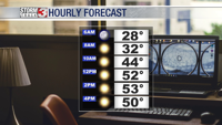
CARTERVILLE (WSIL) �� Brr! Friday morning temperatures are the coldest they’ve been since March 6th! Early morning temperatures are in the lower 20s with wind chills running back into the teens.
Sunshine is expected for much of the day, but the afternoon temperatures will only be in the upper 30s. A few clouds are possible later this afternoon when an upper-level disturbance passes to our north.
Winds shift to the south for the weekend bringing warmer weather our way. Saturday morning temperatures begin in the mid 20s, but by the afternoon, the mercury will climb into the lower 50s.
Sunday is the warmest day in the 7 day forecast.
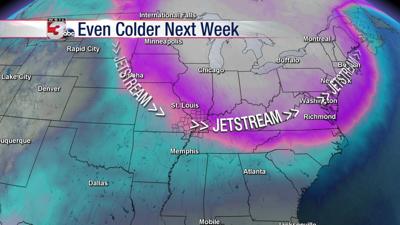
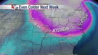
We’re tracking potential for rain turning to light sleet or snow on Monday as another Arctic cold front arrives. By the middle of next week, near record or even record breaking cold will be gripping the region.
Meteorologist Nick Hausen has the latest on how cold we’ll get on News 3.