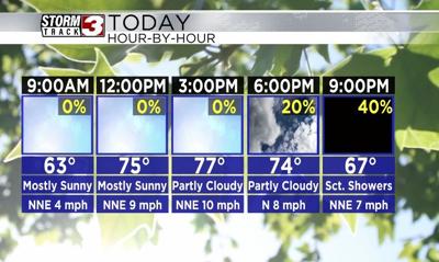
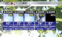


WSIL(Carterville, Ill.)-- This morning, conditions are relatively calm with mostly clear skies and lows in the upper 50s and lower 60s. Most of the day today will be mild with mostly sunny skies and temperatures in the upper 70s for highs.
All eyes today are on the Florida coast, where Hurricane Helene is now a strong category 1 hurricane. Today, it is expected to rapidly intensify into a major category 4 hurricane before making landfall late this evening. It will rapidly move north, and, after about 4 to 5PM this evening, we will first see clouds move in from the east and skies will turn mostly cloudy. A few isolated showers are possible after 6PM but scattered showers should hold off until after 9PM this evening.
Widespread rain will move in after midnight and will last through the entire day tomorrow. Within the heavier rain bands, we could see strong sustained winds between 20 to 25 miles per hour,. Gusts likely will be as high as 40 miles per hour, and depending on the track of Helene, winds gusts over 45 miles per hour are possible if the Appalachian Mountains do not shred the remanits too much.
There is also the potential for flash flooding. However, the soil is still relatively dry, so, this should limit flash flooding. In terms of severe weather, there is a fairly minimal risk of severe weather with this tropical system.
Widespread rain will last through the morning hours on Saturday, but showers will become more scattered as we go through the day and more isolated through the day on Sunday.
When all is set and done, 2-4 inches are possible, with locally higher totals expected. Temperatures through tomorrow and the weekend will be in the upper 69s and lower 70s.