
CAPE GIRARDEAU, Mo. -- Major flooding in northern Illinois and eastern Iowa last week has made its way down the Mississippi River and is impacting the local region.
The National Water Prediction Service (NWPS) on Wednesday, July 3, showed the Mississippi River reaching the major status threshold in communities including Keithsburg, Illinois, Burlington, Iowa, Rock Island, Illinois, and more.
Those floodwaters now have made their way downstream which is hitting areas along the Mississippi River, including Chester, Illinois, and Cape Girardeau, Missouri.
The National Water Prediction Service updated their prediction after rainfall hit the region recently. On July 8, the river levels at Chester are cresting. As of 9 a.m., the river sits at 33.27 feet. This is considered minor flooding and is more than a foot short of the moderate flooding status.
The river level at Chester is predicted to drop below flood stage on July 18.
NWPS also predicts river levels at Cape Girardeau are to crest at 37 feet on July 10, at 7 a.m., according to a chart on July 8.
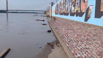
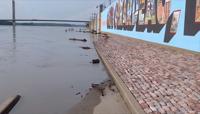
On Monday, July 8, the Mississippi River was already reaching the floodwall in Cape Girardeau with one river gate closed.
The predicted flood level of 37 feet would reach the moderate flooding status at Cape Girardeau.
Flooding is expected to remain through July 17 when the levels drop below 32 feet.
A flood warning has been issued by the National Weather Service in Paducah for the Cape Girardeau area.
A flood warning has also been issued by the National Weather Service in St. Louis for areas along the Mississippi River for the Chester area.