

CARTERVILLE (WSIL) -- It was a very warm January afternoon, hopefully you got a chance to enjoy it. Our next storm system will move through tonight, bringing a chance for strong storms and a big cool down.

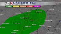
Storms will begin to move into the region after midnight tonight. The Storm Prediction Center has much of area under a marginal risk, through the overnight hours. Make sure you go to bed with multiple ways to get alerts.
Storms will begin in southeast Missouri and move east through the very early morning, when most of us are sleeping. The primary threats will be isolated damaging wind gusts, hail and lightning. Off and on showers will then linger through Thursday afternoon.

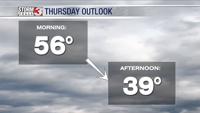
Much cooler air will settle in with this system. It's about to feel a lot more like winter. Tomorrow morning will be warm, into the mid to upper 50s but by the afternoon temperatures will dip back into the upper 30s.
The cool down is short lived. Above average temperatures will return by next week.