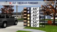


WSIL (Carterville) -- It's that time of the year where dressing in layers is your best friend. We're waking up to lows down in the low 40s which is fairly typical for this time of the year. Sunshine will greet us as we start our Monday and for most of us, will stick around to end it.
A high pressure continues to dominate today which is bringing what's bringing us those blue skies. Highs today will be warm as we climb back into the mid to upper 70s thanks to winds that are out of the southeast.

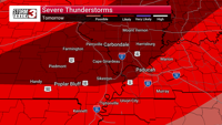
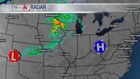
A surface low is continuing to develop over the Plains which will be the big influence for us midweek. It'll steer our winds out of the south and will bring the return of clouds.
Early Tuesday also brings the chance for isolated showers for southeastern Missouri through the northwestern portion of southern Illinois.

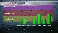
Rain chances are off and on through late week and even this weekend. Unfortunate timing with Halloweekend, but it's still early so hopefully we see the timing change. You may also want to find