

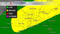


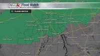


WSIL -- A Flood Watch is in effect for southeast Missouri and southern Illinois until 6 p.m. Thursday evening.

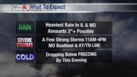
Heavy rain is likely with 2-3" possible and localized amounts could top 3".

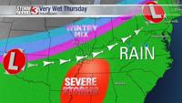
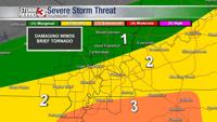
Strong storms are possible 11 a.m. to 4 p.m. in the Missouri Bootheel, western Kentucky, and northwest Tennessee. The main threat is damaging winds, but a tornado or two can't be ruled out, especially near the Kentucky/Tennessee line.

Very mild this morning, but as a cold front works south this afternoon, temperatures will begin to fall this afternoon. Temps in the 30s are expected in parts of southern Illinois by mid to late afternoon.
Strong winds out of the south this morning will turn to the northwest by this afternoon across southern Illinois and southeast Missouri. Farther south, gusts from the south could approach 50 miles per hour outside of thunderstorms ahead of the cold front.

After sunset, rain may briefly switch to light sleet or light snow before ending. A few icy roads could develop tonight in the wake of the heavy rain and the rapid drop in temperatures.