


CARTERVILLE, Ill. (WSIL) -- Sunshine for our Saturday but more chances of showers and storms will be back.


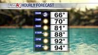
Saturday: Morning lows into the lower to mid 60's with afternoon highs forecast to reach into the lower to mid 90's with humidity on the rise. Early morning areas of patchy fog, eventually clearing by sunrise. Mostly sunny, a few passing clouds. Winds light from the S 5-10mph at times gusting over 15mph.
A heat advisory has been posted for portions of southeastern Missouri. As afternoon highs climb into the lower to mid 90's, heat index values will make temperatures feel like it's into the triple digits. Hydrate and stay cool!
Heat advisory from 10 AM - Sunday 8 PM
Winds towards the evening hours picking up ahead of our next system. A few showers and storms will be possible.

Sunday: Morning lows into the upper 60's to lower 70's with afternoon highs forecast to reach into the lower to mid 90's with more humidity on the way. A few showers and storms will be likely, some could be on the strong to severe side. A complex of storms will move through the region bringing the potential for damaging winds, large hail, heavy rain and a small tornado risk can't be ruled out.
Winds from the SW changing from the W 10-15mph at times gusting more than 20mph.
Monday: Morning lows into the lower to mid 60's with afternoon highs into the lower to mid 80's. A few passing clouds, but mostly sunny. Winds from the WNW 5-10mph with a few gusts over 15mph.

Looking further ahead to next week, conditions look to stay relatively dry.
On the go? Don't forget to Download the Storm Track 3 App. You can download it for free on Google Play or the Apple App Store.