

CARTERVILLE, Ill. (WSIL) �� The potential for some severe weather continues for the area tonight and tomorrow.
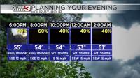
Chances for rain and even the potential for a storm or two will continue through the evening hours tonight with temps steadily declining into the 70s. We are in a level 1 Marginal risk for severe weather for today.
Cloudy conditions will continue and winds will be in the range of 10 - 15 mph.
For Thursday, we again have a level 1 Marginal risk for severe weather for all of southeast Missouri and southern Illinois. We have a potential for rain in the morning hours with scattered thunderstorms throughout the afternoon hours and into the evening. Temperatures will start out in the 60s and top out in the mid 70s. Winds will be around 10 - 15 mph throughout most of the day.
On Friday, shower chances will continue throughout the entire day. The rain should completely exit the region in the early morning hours on Saturday. Temperatures for Friday should be in the 60s for the entire day.
Temperatures should be pleasant this weekend with partly cloudy conditions on Saturday and mostly sunny for Sunday.