


WSIL(Carterville, Ill.) -- This morning, we are tracking mostly clear skies with temperatures that are in the mid 30s across most of the area. winds are mostly calm.
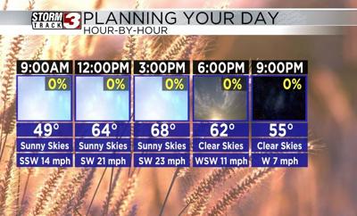
Today, we will see sunny skies last all day today. Temperatures will be in the mid 60s by the midday hours, and highs will be in the upper 60s to lower 70s areawide. Winds today will additionally be on the breezy side, with winds out of the southwest at 15 to 25 miles per hour, gusting as high as 35 miles per hour. Relative humidity will be relatively low as well, only running around 20 to 25 percent. Given this, we will see an elevated fire risk through the afternoon, so outdoor burning should be avoided.
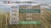
Overnight, we are tracking a cold front that will push through the area. This will cause temperatures to fall to near the freezing level for Saturday Morning. Highs tomorrow will be in the mid 40s, and he cooler weather will continue through Sunday.
Early next week, we are tracking temperatures that will be in the mid to upper 60s Monday and Tuesday, with a few chances for storms on Tuesday. A few storms could be on the strong side.