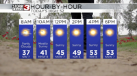


WSIL(Carterville, IL)-- A lot of us are waking up to chilly temperatures that are in the 30s with mostly clear skies.
In our southernmost counties, around the bootheel of Missouri and northwestern Tennessee, there is a frost advisory in effect through 9:00 AM.
Today, you can expect to see temperatures that will warm into the 40s by lunchtime, and into the upper 40s and lower 50s for afternoon highs.
Skies will be sunny through the afternoon and clear through the overnight hours. Clear conditions through the overnight hours will lead to near freezing temperatures tomorrow morning, much like what we are waking up to today.
Highs tomorrow will warm into the low to mid 60s, with sunny skies once again.
The warming trend will start tomorrow, and last into the weekend, with highs likely running in the 70s. We will be remaining dry until sunday, when a few isolated showers are possible, before more rain and storms enter the area next week.