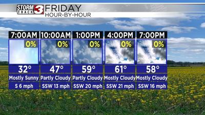


WSIL(Carterville, Ill.) -- This morning, we are tracking temperatures that are on the cold side. Most places are reporting temperatures that are in the lower 30s to near the freezing mark. Skies are mostly sunny to partly cloudy. Winds are also mostly calm across the area. However, through the rest of the morning and afternoon hours, we do expect winds to increase, and be sustained out of the southwest at 15 to 20 miles per hour, with gusts that could be as high as 30 to 35 miles per hour.
Given how strong winds will be today and how dry the air will be, there is a Red Flag warning in place now through 7 this evening for elevated fire weather conditions. Just because southern Illinois and western Kentucky are not included does not mean there is not cause for concern. The entire region should use extreme caution or avoid burning all together.
Through the afternoon, we are tracking temperatures that will warm into the low to mid 60s, under mostly cloudy skies. Despite the cloud cover, nop rain is expected. For your Friday evening, we are tracking temperatures that will gradually return to the mid 50s by 7 or 8, under partly cloudy skies. Overnight, we should see clouds clear and this will help temperatures return to the lower 40s and upper 30s early tomorrow morning.
Skies will be mostly sunny to kick off the day Saturday and remain mostly sunny through the majority of the day. This will help temperatures warm into the mid to upper 60s for afternoon high temperatures. Cloud cover will build back into the area tomorrow evening through the overnight hours. This will be associated with our next system.
While a few isolated showers are possible Saturday late, the bulk of the shower and thunderstorm activity will arrive for Sunday, especially in the late morning through the afternoon hours. A few thunderstorms are possible, but nothing severe is expected. Temperatures for Sunday will reach the lower 60s for highs. A very spring pattern will dominate next week with highs in the mid to upper 60s every day.