


WSIL(Carterville, Ill.)-- This morning, most of us are waking up to mostly clear skies and temperatures in the mid 60s and low 70s further south.
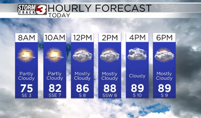
As we go throughout Friday, we will see temperatures rapidly warm, and we will likely be in the mid 80s as early as the midday in the mid 80s with heat index aules in the upper 80s and lower 90s.
Highs today will be in the low 90s for most of us, with heat index values expected to top out in the upper 90s and low 100s, especially in areas in further south in western Kentucky and far southeastern Missouri.
You can expected to see skies go from mostly sunny to partly cloudy this afternoon. Despite a little more cloud cover, we should remain dry this afternoon.
After midnight, we could see a few isolated showers and storms, and they will likely last through the first half of the day. Tomorrow morning, we will likely see temperatures in the upper 70s and lower 80s as early as 8:00 am.
We will see a break in the shower and thunderstorm activity late in the afternoon, and we may even see the sun poke out. Highs tomorrow will be in the low to mid 90s with heat index values in the low 100s.
With the heating of the day we will see scattered shower and storms form and track from west to east. There is a low end risk that one or two storms could be strong to severe, with the main hazard being damaging winds.
Rain showers will last Sunday, but it will be cooler with highs in the upper 80s.