

WSIL(Carterville, Ill.) -- This morning, most of us are waking up to temperatures that are well above normal, with most locations reporting the upper 50s and lower 60s. We are also seeing gusty winds at 5 to 15 miles per hour, with gusts up to 20 miles per hour.
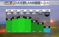
For today, you can expect to see mostly cloudy skies last through most of the day. Gusty winds, out of the south, will stick around, with sustained winds at 10-15 miles per hour, with gusts reaching 20 to 30 miles per hour. Temperatures through the lunchtime hour should reach the lower to mid 60s, but by 3PM, temperatures will return to the mid 50s.
This will be due to a cold front passing through the region this afternoon. As the cold front passes through the area, there is a chance of scattered showers. However, there is not too much moisture to work with, so showers should remain light. The best window for showers will be between 12PM and 6PM, but once the front passes, conditions will be dry. Sustained winds at 10-15 miles per hour, with gusts reaching 20 to 30 miles per hour, will be possible behind the front though the evening, cand calming overnight.
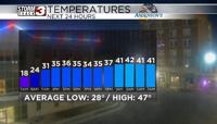
Tomorrow, the cold front should bring colder temperatures. Morning lows will be in the lower 30s and upper 20s tomorrow, and highs should reach the upper 40s and lower 50s. Skies tomorrow will be mostly sunny thanks to an area of high pressure. The 50s will stick around for Wednesday, but another system will push through the region late Wednesday into Thursday. This will bring a few chances for showers late Wednesday evening and into Thursday morning. Temperatures for Thursday will be in the lower 40s for highs and as we approach the end of the workweek and weekend, will be in the upper 30s.