

WSIL(Carterville, Ill.) -- This morning we are tracking light snow showers across southern Illinois. This morning, we will continue to see isolated snow showers. Some light accumulations can be expected, but the bulk of the heavy snow will enter into the region after 12 this afternoon. For this heavy snow, there is a Winter Storm Warning in place from 9 AM this morning through 9 AM tomorrow morning.
This afternoon, we will start to see heavy snow push into the region in a west to east fashion. It should enter southeastern Missouri between 12 and 1 this afternoon, and into far western Illinois between 2 and 3. By 4 or 5 this evening, the entire region is expected to see widespread moderate to heavy snow. This will persist into the overnight hours, into early tomorrow morning. Snow is not expected to end until after 6 AM tomorrow morning.
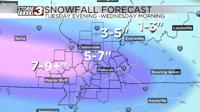
In terms of accumulations, we are tracking the potential for 4 to 8 inches of snow on average. Locally higher totals are expected along a corridor somewhere in southeastern Missouri through southwestern Illinois, and adjacent areas of western Kentucky. Areas further north of Benton could see less in terms of accumulations, as there will be less atmospheric moisture. We expect 3-4 inches on average. Regardless though, everyone will see snow today.
Behind this system, we are tracking a couple of isolated flurries that will stick around through the afternoon hours tomorrow, but minimal accumulations are expected. In addition to the snow, we are going to see gusty winds with this system, potentially gusting to 25 miles per hour.
Behind this system, it is going to be cold. Temperatures today will only top out in the low 20s. The mid teens are expected for tomorrow and Thursday, with morning lows that could be between -5 and -10.