
The Role of the National Weather Service
The National Weather Service (NWS) Paducah Office is an essential entity in providing weather safety and preparedness across four states. This article offers a glimpse into the significant work carried out by the NWS, focusing on insights from an interview with Warning Coordination Meteorologist Christine Wielgos conducted by StormTrack 3 Meteorologist Garrett Hamilton.
Operational Dynamics of Weather Forecasting
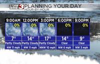
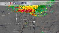
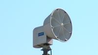
At the heart of the NWS Paducah Office's mission is the development of accurate weather forecasts. "We watch over those 58 counties each and every day, day in and day out. So we never close," Wielgos states, underscoring the office's commitment to continuous monitoring. The National Weather Service Forecast Office's (NWS FO) approach to forecasting is founded on a rigorous analysis of data from various sources. Meteorologists at forecast offices across the country analyze radar data to detect imminent weather patterns, paying close attention to any indications of severe weather such as supercell thunderstorms that often precede tornadoes.
The National Weather Service Forecast Offices (NWS FOs) coordinate closely with the National Severe Storms Forecast Center, which is officially known as the Storm Prediction Center (SPC). The SPC specializes in the surveillance and prediction of convective severe weather, including tornadoes, severe thunderstorms, and hail across the United States.
When potential severe weather conditions are identified, the SPC issues outlooks, watches, and mesoscale discussions, which are then used by local NWS FOs to inform their specific forecasts and warnings. For example, if the SPC issues a tornado watch, the NWS FO in the affected area will disseminate this information to the public and may follow up with their own localized warnings based on the latest radar data and ground reports. This collaborative effort ensures a comprehensive and coordinated response to severe weather, maximizing the effectiveness of warnings and the safety of the public.
Decision-Making/Weather Watches and Warnings
In the realm of severe weather prediction, the issuance of watches and warnings is a critical task. Wielgos explains, "A Tornado Watch is issued whenever the conditions are present for severe weather... all the parameters that we need for severe weather and or tornadoes are coming together to where we want to put out kind of a wide net."
A "Particularly Dangerous Situation" (PDS) tag is an enhanced type of weather watch that the Storm Prediction Center (SPC) can include within its tornado or severe thunderstorm watches. The PDS designation is reserved for situations where long-lived, widespread, and particularly intense severe weather events are expected. These can include high-end tornado outbreaks or severe wind events (derechos) with destructive wind gusts that could cause significant damage.
When a PDS watch is issued, it signifies that the potential for severe weather is not only high but that the severity and/or coverage of the weather events could be life- threatening. It serves as a heightened alert to emergency management, the public, and other stakeholders to take immediate precautions due to the increased likelihood of very dangerous weather conditions.
The PDS tag prompts more urgent and proactive responses, as it indicates confidence in the forecast of extreme severe weather events. For instance, in the case of a PDS tornado watch, there is a higher probability of multiple strong (EF2 or greater) tornadoes. This kind of watch is not common and is only used when meteorological data suggests an unusually severe threat is imminent, making it a critical tool for communicating risk in the most dangerous weather scenarios.
Public Preparedness for Severe Weather
The NWS places high importance on public readiness. "You're not going to have time and your mind is not going to be working clearly during an event... So having a plan ahead of time... and you practice that plan, so you know exactly what you're doing and you're not wasting precious time," advises Wielgos. To , the National Weather Service (NWS) and recommend for the public:
1. Stay Informed: Regularly check the forecast to assess the risk of severe weather. Utilize local news or NOAA Weather Radios to stay updated on severe thunderstorm watches and warnings.
2. Notification Systems: Familiarize yourself with how your community sends warnings, whether it’s through outdoor sirens, media, or smartphones.
3. Communication Plan: Have a family emergency plan that includes a designated meeting place and relevant contact information. Choose a safe room in your home, such as a basement, storm cellar, or an interior room on the lowest floor without windows.
4. Practice Drills: Regularly conduct severe thunderstorm drills with your family so everyone knows where to go and what to do if a storm is approaching. Include pets in your plan if time allows.
5. Secure Your Home: Trim trees and branches near your house and secure loose objects to minimize damage and injury from high winds.
6. Support Network: Help neighbors and loved ones prepare and consider learning CPR to assist in the event someone is injured during severe weather.
7. Emergency Kit: Prepare a kit with essentials such as water, non-perishable food, medications, and important documents in case you need to act quickly.
8. Awareness: Be a "Force of Nature" by promoting severe weather preparedness in your community.
Coordinated Response During Severe Weather
When severe weather occurs, the response from the NWS is immediate and coordinated. Wielgos describes the environment: "There's so much chaos. But everybody knows their job, and everyone knows their position and what they're supposed to be doing." In this environment, meteorologists monitor radar imagery and atmospheric conditions to track storm development and behavior. They must discern between false echoes and actual threats, a task that requires extensive skill and experience. Communication specialists disseminate timely warnings to the public and liaise with emergency management agencies, ensuring that the message of impending severe weather reaches as many people as possible. Behind the scenes, hydrologists may be involved in assessing the risk of flash flooding, while IT professionals ensure that the computer models and communication networks are functioning flawlessly to support these activities.
The coordination is further extended through the integration of reports from the field. Trained storm spotters and the public provide ground-truth reports that can confirm radar indications of tornadoes, hail, or wind damage, which meteorologists then use to update their forecasts and warnings. This collaboration between the office and its partners is crucial to maintaining situational awareness and can make all the difference in safeguarding communities.
Post-Event Analysis and Damage Assessment
Following severe weather, NWS's work shifts to analyzing the aftermath. Wielgos discusses the importance of damage assessment: "We go out in teams of two... checking out damage." Teams meticulously survey affected areas to collect data on the impact of the storm. This involves identifying the path of the storm, measuring the length and width of its impact, and closely examining the nature of the damage incurred.
Wielgos notes the methodical approach taken: “You're trying to find the beginning where it started, you're trying to figure out where it ended. You're trying to figure out how long your path was, how wide your path was, and then by looking at the damage that was done, we're trying to figure out the strength of the winds.�� This information is crucial not only for classifying the storm using the Enhanced Fujita Scale but also for improving future forecasts and warnings. By understanding the characteristics and behaviors of past storms, meteorologists can refine their models and better predict how similar weather patterns may behave, which in turn leads to more effective warnings and community preparedness in the future.
Essential Operations of NWS Paducah During Severe Weather Events
The NWS Paducah's crucial role spans the full spectrum of severe weather scenarios, executing tasks from advanced forecasting to the final stages of damage evaluation. The systematic collaboration with the Storm Prediction Center for predictive alerts and the execution of emergency response strategies demonstrate a high level of preparedness and adaptability. As Christine Wielgos' insights reveal, it's a concerted effort combining the vigilance of meteorologists, the precision of data analysis, and the responsiveness of emergency communication systems. The NWS's commitment to public preparedness, ongoing education, and rigorous damage assessment practices ensures that each storm leaves behind not just a trail of recovery but also a wealth of knowledge to better equip us for the next weather challenge.
Further Reading:
1. National Weather Service Paducah Office: NWS Paducah
2. Storm Prediction Center: SPC
3. Severe Weather Preparedness: Severe Weather
4. National Weather Service Safety Tips: NWS Thunderstorm Safety
5. Federal Emergency Management Agency (FEMA): FEMA