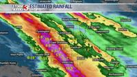
CARTERVILLE, Ill. (WSIL) -- It looks like we will have a rainy and stormy Easter ahead, with most of the severe weather likely in the evening hours.
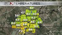
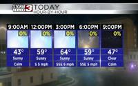
The area is facing another threat of severe storms. We will start out early with some chances for rain and clouds. If you are planning to attend any Easter services in the morning outside, you may want to bring an umbrella just in case. The rain should taper off some throughout the day, however, the storms settle back in tonight. Temperatures will start out in the 60s and climb into the upper 70s by the afternoon.
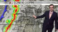
By Sunday evening, storms are expected to arrive and look to be severe at times.
A level 2 Slight risk for severe weather is in place for most of southeast Missouri, excluding Mississippi, New Madrid, Scott and Pemiscot Counties. The level 2 risk also applies to Randolph County and the western portion of Jackson County.
A level 1 Marginal risk affects the rest of the region, except for Gallatin, White and Hardin Counties in Illinois and Calloway, Crittenden, Caldwell, Graves, Marshall, the eastern portion of McCracken and Lyon counties in Kentucky.
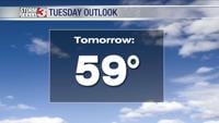
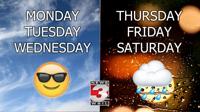
On Monday, rain and thunderstorms are expected to taper off in the early morning. Temperatures will climb into the upper 60s with some areas hitting the 70 mark. Clouds will also move out some making for partly cloudy conditions.