

Carterville (WSIL) -- Clouds finally decided to stretch across our region this afternoon. Of course not before allowing our temperatures to rise into the mid and upper 50s for highs again for many in the region. We will progressively get more cloudy as the night goes on and with a strong southerly flow taking hold, we will remain in the upper 40s for our low temperatures tonight.
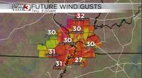
As you wake up tomorrow, winds across the region will be quite gusty at times with wind gusts around 20 mph. These winds will be coming from the south so despite us being mostly cloudy we will again reach temperatures in the mid to upper 50 category. The afternoon should feature the strongest wind gusts with 30 mph gusts across much of the region. Winds will remain strong until we get to Friday morning where they should taper off.

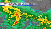
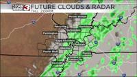
In terms of rainfall Thursday, it looks meager at the moment. The timing of the rain appears to be quicker with isolated showers arriving around 10 AM for our western counties and near 12-2 PM for our eastern counties. The showers appear light and quite isolated so I don't expect them to cause problems for anyone travel wise.
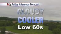
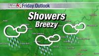
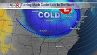
Friday looks to be our warmest day with our southerly flow continuing and some sunshine peaking through the leftover clouds. High temperatures in the upper 60s with a nighttime low in the mid 40s. Friday definitely the best day of the week so get out and enjoy it before we get cold again next week.