WSIL -- Enjoy a mild Monday as we're in for a wild weather ride this week!
Sunny skies will help warm temperatures this afternoon into the upper 60s, marking the WARMEST day of the week!

A potent late season cold front will arrive this evening, dropping temperatures into the lower 40s across southern Illinois by Tuesday morning. This front is likely to stall around the Ohio River and even retreat north a bit Tuesday afternoon.
This stalled front will likely keep temperatures in the upper 40s in Mt. Vernon Tuesday, while a few areas could approach 70º in western Kentucky.

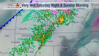
All eyes are on a system that will bring a round of showers by Tuesday evening. Rain is likely to begin, but a quick change over to heavy wet SNOW is expected, especially in southern Illinois and southeast Missouri.

While impacts on roads are unlikely, a quick dusting may develop on grass before the snow wraps up.

Snow in the second half of April is rare. The last time it happened was April 16, 2018 when a "trace" was measured. The biggest and latest snow on record occurred April 25, 1910 when 7" of snow was measured in Marion!

A FREEZE WATCH has been issued Wednesday morning for parts of southern Illinois and southeast Missouri.

As the snow ends, temperatures will continue to fall, bottoming out in the upper 20s in areas north of Route 13. This is enough to possible cause damage to more sensitive flowers.
Thursday morning will also bring the risk of frost.