
CARTERVILLE, Ill. (WSIL) -- We are keeping an eye on severe weather which is expected to enter our region start as soon as tonight.
As you wake up this morning, we will have sustained winds at nearly 20 mph out of the south-southwest. This will stick around throughout the day. Temps will rise and hit highs in the upper 70s.
Winds won't calm much tonight but will hang around between 10 - 15 mph. Storm chances increase during the night hours as well.
We have a Level 2 risk for storms across some of our southern Illinois counites in the northern portion of our coverage area for late Friday night. This includes a small portion of our northern counties in southern Illinois, along with portions of some of our northern counties in our coverage area in southeast Missouri.
The rest of southern Illinois and most of southeast Missouri, along with the northern portion of western Kentucky, have a level 1 risk for severe storms.
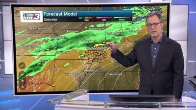
On Saturday, a small portion of our southeast Missouri counties are in a level 2 Slight risk for severe weather. The rest of our coverage area is in a level 1 Marginal risk for severe weather.
For Saturday, you can expect potential hazards including damaging wind gusts and heavy rain in the early afternoon to evening hours.
On Sunday, the 15-29% probability for severe weather threat will be for all of southeast Missouri, the western half of southern Illinois and the four most western counties of western Kentucky.