Much of the region has now been upgraded to a Winter Storm Warning. Click here for the latest.
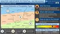
CARTERVILLE, Ill. (WSIL) �� A Winter Storm Watch has been issued for much of the region for Tuesday into Wednesday with forecasted snow expected to bring multiple inches to the area.
Heavy snow is possible with accumulations between 4 to 9 inches.
This snow storm will affect southern Illinois, southeast Missouri and western Kentucky, starting from late Monday night and into Wednesday morning.
Roads, bridges and overpasses will more than likely be very slick and hazardous. Travel also could be very difficult with this winter storm system.
Very cold temperatures will follow the snow event and will stick around throughout the week.
Make plans now and everyone should stay off the roads, if possible, during this snow event. If you have to get out, drive with extreme caution.
The Winter Storm Watch includes the following counties��
Illinois: Jefferson; Wayne; Edwards; Wabash; Perry; Franklin; Hamilton; White; Jackson; Williamson; Saline; Gallatin; Union; Johnson; Pope; Hardin; Alexander; Pulaski; Massac.
Kentucky: Fulton; Hickman; Carlisle; Ballard; McCracken; Graves; Livingston; Marshall; Calloway; Crittenden; Lyon; Trigg; Caldwell.
Missouri: Perry; Bollinger; Cape Girardeau; Wayne; Carter; Ripley; Butler; Stoddard; Scott; Mississippi; New Madrid.