

CARTERVILLE (WSIL) -- It was quiet start to the work week but big changes are around the corner.
The quiet weather will stick around overnight with low temperatures dipping into the 30s. Tuesday will be a very warm day as we kick off February. High temperatures will climb well above normal, into the upper 50s.
The chance for rain will make it's way back into the region by the afternoon and even hours. Rain will then ramp up through the day on Wednesday, followed by a transition to a wintry mix.
Rain, freezing rain and sleet will be the main concerns through the remainder of the week. Where the freezing rain and sleet line up within the region are TBD. However, this system will likely cause disruptions in your day to day activities, with the biggest impact expected Thursday.
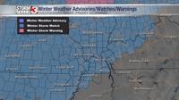
A Winter Storm Watch has already been issued for portions of the region Wednesday night through early Friday morning.
The Storm Track 3 Team will be tracking this system all week. Stay weather aware.
If you haven't already, click here to download our Storm Track 3 app!