


WSIL -- A Dense Fog Advisory is in effect this morning until 9 a.m. Patchy, but very thick fog is reducing visibility to less than one mile in some locations. Allow extra time, use low-beam headlights, slow down, and keep a watchful eye.

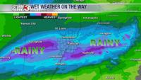
As a stalled front moves back and forth across the region over the next few days, rain chances will also waver back and forth. As a disturbance approaches this afternoon, the front will lift north as a warm front. This will bring a good chance for showers, especially during the afternoon and early evening. Most of the rain will be very light with amounts of only around 0.10-0.25" across much of southern Illinois and southeast Missouri.

Once the disturbance moves east, the front will go back south as a cold front, setting up in the Missouri Bootheel and northwest Tennessee by Wednesday morning. This will keep most of the rain focused in the far southern reaches of our viewing area.
A stronger disturbance will track into the region on Thursday. This will once again lift the front back north, shifting more rain into the area. Thursday will be the wettest day of the week with round of widespread rain and occasional thunder.

By Thursday night, the front goes back south, shifting the rain out of the region again.