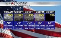
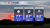
Carterville (WSIL) -- Another dry day today in which winds did pick up coming from the SE. This has brought warmer temperatures in the low 60s across the area. But it also has increased fire weather danger for today. Clouds also will be on the increase through tonight as our cold front approaches for tomorrow.
Tomorrow we already have Wind Advisories up for the entire viewing area starting from 5AM ending Tuesday at 5AM. This is for the potential to see strong sustained winds of 20-30 MPH and wind gusts around 45-50 MPH. These winds are strong enough to blow away any loose and untied objects in and around your yard and also has the potential to knock down tree limbs and cause sporadic power outages across the area.

These winds will be maximized as the cold front approaches in the evening. This is when the best chance for consistent gusts around 45-50 MPH will be possible although, they can occur at any time of the day.
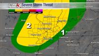
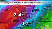
This cold front also brings with it widespread heavy rainfall from about 6PM Monday evening - 1AM Tuesday morning. Expect general rainfall amounts of 1-2 inches across much of the area.
Tuesday morning there may be a few scattered showers around along with some breezy conditions but nothing like Monday. I expect us to dry out as we head into the afternoon.