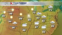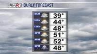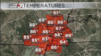


Carterville Ill. (WSIL) -- Early cloudy skies have broken up somewhat in a few locations across the region this afternoon. This has allowed temperatures to increase to around 90 for a few areas. The early signs of increasing heat are upon us. Every day clouds will get few are far between allowing temperatures to skyrocket into the mid and upper 90s again by the end of the week.

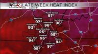
Lucky for us, the dew point wont be as high at the end of the week when temperatures are greatest. This allows the heat index to remain pretty close to what the real temperatures are. Don't get me wrong, we are still going to be humid but just not enough to get our real feel temperatures above the 105 limit. Still, with temperatures around 95-97 by Friday and Saturday you will want to make sure you're staying hydrated and taking plenty of breaks if you have outdoor activities you're planning.
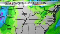
Next chance for a little relief will be on Sunday when a cold front approaches. With it the chance for increased cloud cover and some rain chances will come back to the region helping keep temperatures lower again.