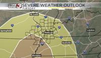
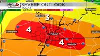
CARTERVILLE (WSIL) -- Spring is in the air. As our next storm system moves through the chance for severe storms ramps up throughout the evening.
A cold front is expected to push through the region this evening ramping up the chance for storms. Strong to severe thunderstorms cannot be ruled out with the highest chances in the Missouri bootheel, western Kentucky and northwest Tennessee.
The National Weather Service has issued a Tornado Watch for portions of the region until 10 PM tonight. The main hazards include flooding, damaging winds, hail and isolated tornadoes. Be sure to stay weather aware.
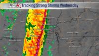
The Storm Track 3 Team will be tracking this system tonight on News 3. Stay tuned for updates.